Origin of war
In 1991, during the Gulf War, the GPS satellite system, as a rarity, was used in actual combat for the first time and became an instant hit. This war is an anti-traditional method of warfare. The United States has sacrificed a large number of precision-guided weapons against Iraq, and the hit rate of 288 “Tomahawks” is as high as 98%. As a result, the war came to an end in only 42 days at the cost of 146 U.S. troops killed and 467 wounded, while Iraqi troops suffered more than 100,000 casualties.
Since this is a war in an unfamiliar area across the sea, and the Iraqi side has more than 5,800 tanks, more than 4,600 armored vehicles and infantry fighting vehicles, and 30,000 artillery pieces, many global military scientists initially predicted that it would be a stalemate. It also includes Zhang Zhaozhong, the seat of the bureau. Unexpectedly, in just 42 days, it turned into a unilateral dimensionality reduction massacre by the United States against Iraq! Afterwards, in the summary report of the war, the United States even attributed the victory of the Gulf War to “the victory of GPS”. The Gulf War made the world see what is called a modern war, and the subsequent Iraq War, with the aid of the GPS system, became a big show of super weapons. Precision guidance, stealth bomber bombing, electromagnetic interference…
The most tragic scene was a tank unit, which was instantly turned into scrap metal. Several kilometers long were abandoned tanks. The scene was terrible.
In this battle, Iraq’s so-called million-strong army was almost like a weak chicken in front of the US military, and could not organize a strong resistance at all.

As the saying goes, money is the blood of war, and intelligence is the nerve of war. If you can’t catch the enemy’s trail and you can’t figure out the enemy’s strategic deployment, you won’t be able to take the initiative in the battlefield. In the Gulf War, the US GPS with a positioning accuracy of up to 0.3 meters was like the eye of God, controlling the entire battlefield situation: satellite reconnaissance and positioning, troop mobilization, material support, battlefield rescue, firepower coordination, and precision guided weapons. The system completely changed the form of warfare, and also gave birth to a new term in the military academia – “surgical strike”.
When the war in Afghanistan came, the military application of GPS completely formed the ability to systematize the sea, land and air. In October 2001, the U.S.-British coalition began to carry out large-scale air strikes and carpet bombings in Afghanistan, reproducing the tragic scene of the Gulf War. During this period, the bombs were thrown accurately, but also depended on GPS satellites. So how important is GPS to the United States? The former chairman of the Joint Chiefs of Staff of the United States once said that without the support of the GPS system, the United States cannot even win a war. Of course, if a war breaks out one day, the old American turns off the GPS system, and it is a trivial matter that he can’t go back to his hometown for the Chinese New Year. In the worst case, missiles and warships are paralyzed and cannot find the north, and the country is in a security crisis. tears! It’s like in the Middle East battlefield, everyone is using GPS happily, and the United States has turned off the GPS of the enemy country, resulting in a bunch of missiles hitting the sky and flying all over the world.
So it is no exaggeration to say that GPS is essentially a war machine.

Of course, in addition to the value of weapons of war, the application of GPS in the civilian field also shines brightly. However, the civilian-level accuracy and military-level accuracy are only ten times different. The GPS signal of the mobile phone is weak. Is this voice reminder familiar to you? That’s right, this is the GPS used by the map navigation software in your mobile phone.
From communications and telecommunications, vehicle information systems, location services, surveying and mapping, electricity, to even our usual daily life scenarios such as takeaways and dipping, GPS is almost inseparable. In the civilian field, since GPS has entered the application market for more than 20 years, especially under the wave of smart phones, the GPS system has built a huge and complete business ecosystem. Data show that in 2020, the overall output value of my country’s satellite navigation and location service industry will exceed 436 billion yuan. As the industry leader and monopoly, GPS has more than 500 applications.
The US GPS covers the whole world, why does China still develop Beidou independently? The story has to start with the Galaxy incident.

On July 23, 1993, the United States accused China of transporting raw materials for chemical weapons to Iran on the grounds of obtaining intelligence, and threatened to impose sanctions on China. At the same time, the United States also dispatched warships and aircraft to the international high seas where the “Galaxy” is located, in an attempt to intercept it. At one point in the middle, the GPS signal of the Galaxy was directly cut off, causing it to lose its mobility during the high seas voyage.
In the end, the Galaxy can only become a piece of meat on the chopping block, to be slaughtered by others. On September 4, 1993, the last cargo box on the “Galaxy” freighter was inspected and no chemical weapons were found. The “Galaxy” was forced to suspend normal shipping for 33 days. If you fall behind, you will be beaten. It was this humiliating slap from the old beauty that forced my country’s determination to independently develop a satellite navigation system. The news came back to China and made many aerospace scientists and defense personnel realize the importance of autonomous navigation. Afterwards, Sun Jiadong, an academician of the Chinese Academy of Sciences, found Shen Rongjun, then deputy director of the National Defense Science, Technology and Industry Committee, and jointly signed a letter to the state, suggesting that China’s Beidou satellite navigation system should be activated. The development of satellite navigation is urgent and imperative! In December 1994, the Beidou Navigation Experiment Satellite System Project was approved by the state. China is determined to develop its own Beidou system. However, the construction of systematic technical projects is not achieved overnight, nor can it be accomplished overnight. Soon, with no experience and no money, all kinds of predicaments and embarrassment swarmed up, and encountered all kinds of slaps in the face of reality. According to Jiaziguangnian: At that time, the United States had invested more than 20 billion US dollars in GPS projects, and the annual maintenance cost was as high as 500 million US dollars; but at that time, China’s economic foundation was still very weak, and the research and development of technologies in 7 major fields including aerospace The budget of the “863” plan is only 10 billion yuan. The gap between China and the United States in funding for early research and development of navigation systems is more than tenfold. Due to the huge project of the satellite navigation system, those who were able to manage the satellite system at that time were basically only the rights of a few big countries, such as China, which had weak comprehensive national strength and needed to explore the way forward in the process. rise.
Although the process is troublesome, you can’t worry about positioning and navigation satellites. After all, China is an aspiring power. In fact, as early as the early 1980s, we had already proposed the dual-star positioning plan of “two bombs and one satellite”. However, due to the limited economic conditions at that time and the view that “it’s better to buy” was popular in China, the plan was shelved for various reasons. ten years. The year 1991 was a major turning point, and the great performance of GPS in the Gulf War awakened the Chinese people. The decision-making layer deeply realized that it is really impossible to fight without this thing in the future, and the dual-star positioning plan, which had been shelved for ten years, was launched immediately. Despite the huge disparity in strength and overcoming difficulties in the process, the meal must be eaten one bite at a time. At this point, the Beidou system has started to develop, according to the “three-step” development strategy, first active, then passive, first regional and then global, and successively built the Beidou-1, Beidou-2, and Beidou-3 systems, and developed a satellite with Chinese characteristics. Navigation system builds roads. In 2000, although China has successfully launched two Beidou navigation test satellites into the sky to form the “Beidou No. 1” navigation system.
However, it was only after the strength gap with other people’s GPS satellite systems that it was found that it was really incomparable. Not to mention that the “Beidou-1” positioning system itself is only a two-dimensional navigation system, which is relatively slow and can only cover China and some surrounding Asia-Pacific countries and regions. “As soon as the system sends a signal, it is easy for the other party to determine its position, thus exposing itself, so it cannot be used for military purposes, and the use experience is not generally bad. When we were worried about how to make technological breakthroughs in the Beidou satellite system, at this time, the Europeans suddenly proposed to invite China to participate in the European navigation Galileo program. On the one hand, because the project is burning too much money, no single European country can afford it, but they have to do it. The extreme lack of funds also makes progress extremely slow; For China at that time, it was like a pie in the sky. After all, our country was still blank in the field of navigation at that time. In October 2003, China and the EU signed a cooperation agreement. China invested 200 million euros to obtain 20% of the ownership and 100% of the right to use the Galileo system, and can participate in all aspects from satellite manufacturing to user services. Unexpectedly, after the first 70 million euros were put into the pockets of Europeans, China was kicked out of the Galileo plan before the Europeans came to share the core technology of satellite navigation with themselves.
When China realized that it was actually Europeans and Americans who were digging a big hole for China, it was too late. For China, this is undoubtedly a blatant humiliation. In a fit of rage, China broke all illusions, and China fully launched the Beidou-2 system. After all, relying on other countries in terms of military defense is tantamount to letting others put a knife around their necks. It’s like you usually use the neighbor’s WIFI secretly, but one day the neighbor suddenly changed the password. Do you have to be cheeky to ask the neighbor for the password? Fortunately, after the EU kicked China out of the “Galileo Project”, it also fell into internal contradictions, and satellite launches were delayed again and again.
Although Galileo has not yet succeeded, the progress of China’s Beidou satellite system has soared.

Until the second generation of Beidou, which began to change the mode and adopted the same passive mode as GPS, the breakthrough was very obvious. Although in principle, the positioning accuracy of “Beidou II” is almost the same as that of GPS; but GPS has a long use time and may have better performance in all aspects, and its accuracy can reach within 10 meters, while the current accuracy of “Beidou II” is 20 meters. about. Nonetheless, this has also reached the world’s advanced ranks. In order to attract the market, the “Beidou System” is also racking its brains. Although it is not as perfect as GPS, it is also practicing its own advantages and characteristics, that is, the communication function.
To make an inappropriate analogy, if GPS is a sedan, then Beidou is a pickup truck, which can not only pull people, but also carry some goods. Although there is still a certain distance between Beidou and GPS in terms of experience and use points. While Galileo in Europe is still tinkering slowly, the Beidou in China keeps hitting satellites one after another. Later also engaged in a double star. China’s fast pace has caught Europe’s attention. Through the United States, it has put pressure on China to slow down and wait for the European people.
In the past, European and American countries used their technological and economic advantages to seize resources. China’s technological and economic strengths were not strong enough to suffer from dumb losses. You have never yielded, so why do you want me to be humble now? China ignored the protests from Europe and the United States and continued to launch satellites according to the established rhythm. In the Beidou second-generation plan, after the launch of 35 satellites is completed by 2020, a global positioning and navigation system with 5 more satellites than GPS will also be formed. For China, the purpose of launching Beidou-2 is only to seize orbital resources and ensure that the door of the navigation system is not closed to China. Technically, it is still backward and the accuracy is not high. In 2009, China officially launched the Beidou-3 project, preparing to break through all technical barriers and create a super navigation system with extremely high precision, no less than GPS. Eight years later, China has finally completed technical research, breaking through all the technical barriers blocked by Europe and the United States, and has added many special satellites to the GPS system to achieve more powerful functions.
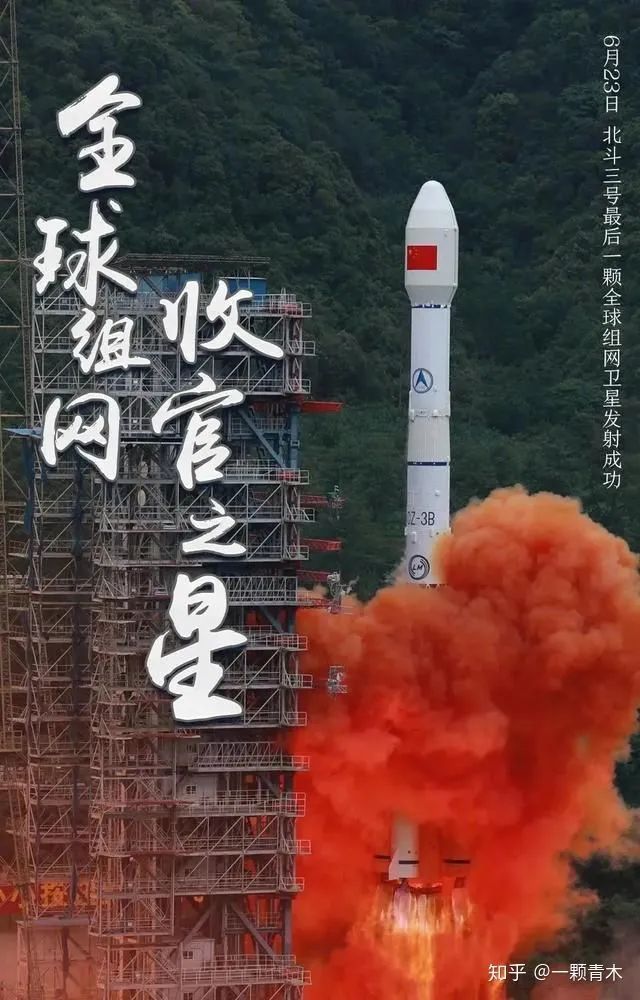
On June 23, the last satellite in the Beidou-3 global satellite navigation system was ignited, and the Beidou global network was finally completed.
From the establishment of the Beidou-1 system project in 1994 to the completion of the Beidou-3 network satellite launch mission, China’s Beidou people have achieved the development and launch of 55 satellites in more than 20 years. In the meantime, the Chinese Beidou people have gone through a arduous journey from “deeply chasing” to “running with their heads held high”, from “being controlled by others” to “independent and controllable”, and from “regional service” to “global guidance”.

Regarding the completion of the Beidou-3 network, Chen Jinpei, CEO of Qianxun Location, said that from the perspective of the capabilities of the navigation system, both the Beidou satellites in the sky and the Beidou ground-based augmentation system on the ground have completely surpassed the maturity of technology and products and services. GPS.
Where is our immaturity today? Chen Jinpei believes that it lies in the industrial chain, including from chips to antennas, smart terminals, and application scenarios, because its integration takes a certain amount of time.
“GPS developed more than 20 years earlier than us, and we have only now been upgraded to a global system. From the perspective of the global industrial chain, we still have a gap.”
On June 23, when Beidou completed the global network, Qianxun Location also announced a major news: “The number of users of Beidou acceleration assisted positioning service independently developed by my country has exceeded 500 million, covering most of the Android phones in China. This service reduces the initial positioning time that takes more than 30 seconds to 3 seconds.” This also makes Qianxun Location the fourth company in the world to master this technology after Apple, Google, and Nokia.
The latest data from Qianxun Location shows that the total number of users of Qianxun Lijian, the world’s first accelerated assisted positioning service supporting the Beidou satellite system, exceeded 500 million, the total number of services exceeded 550 billion, and the daily active users exceeded 100 million. The number of daily services exceeds 1.2 billion, covering more than 230 countries and regions around the world, of which more than 75% of users are from China. This means that out of every 4 Chinese people, 1 uses Beidou acceleration to assist positioning.
From the data provided by Qianxun Location, the number of Beidou satellites currently visible in many countries and regions around the world has surpassed GPS.
From “building Beidou” to “applying Beidou”, it is a brand new journey. Although Beidou still has a long way to go compared to the huge industrial ecology that GPS has already formed, it also means that a huge business opportunity is in front of us: an already 100 billion level, which may reach a trillion scale in the future. The industry is waiting to explode.
Some of the information in the article is referenced from:
“From the beginning of the word “missing” to the completion of the global networking, is Beidou really “out of blue”? 》 The Paper
“Beidou chips only have 500 million users, are you one of them?” Yuan Fang Aoki
“With free GPS, why does China have to spend huge sums of money on “Beidou”? “Veteran dare to say
“Breaking the U.S. monopoly, Beidou can’t even do GPS” Sun Bing from Economic Net
“From being controlled by others to being autonomous and controllable!The Thrilling Behind China’s Beidou Global Network” China Youth Daily
The Links: MG15G1AL2 G065VN01-V1